[id: 107]
Short description: This research aims to apply a geospatial analysis framework to explore the relationship between human mobility and environmental exposure from a geographic perspective. Focusing on identifying spatial patterns and potential impacts of large-scale population movement on environmental exposure changes, this study leverages traditional geographic analysis methods to investigate and analyze key questions in health geography and urban planning. Through this approach, we aim to gain insights that contribute to a nuanced understanding of how human mobility alters exposure risks, offering valuable clues from a spatial perspective.
Keywords: Human Mobility, Environmental Exposure, Geospatial Analysis, LISA, GWR
Topic at: TU Munich
Staff involved: Chuan Chen (chuan.chen@tum.de) ; Peng Luo, MIT
Description:
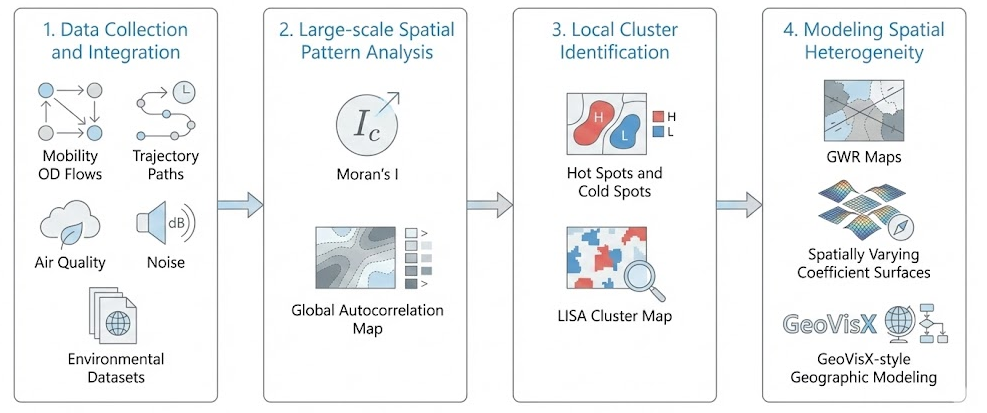
1. Data Collection and Integration: The initial step involves gathering data from multiple sources, such as large-scale mobility datasets (e.g., OD flows or trajectories) and environmental da-tasets (e.g., air quality or noise levels), to build a comprehensive dataset. This dataset will be integrated and standardized to allow for a cohesive analysis of how population movement in-teracts with various environmental factors.
2. Large-scale Spatial Pattern Analysis: The second step uses statistical methods for Large-scale geospatial analysis, specifically applying Moran's I to evaluate the overall spatial autocorrela-tion of exposure changes. By applying these geographic metrics, we aim to determine whether the impact of human mobility on environmental exposure exhibits significant clustering or dis-persion trends across the entire study area.
3. Local Cluster Identification: In the third step, we apply local spatial analysis methods, particu-larly LISA (Local Indicators of Spatial Association), to identify specific hot spots and cold spots of environmental exposure driven by mobility. This step highlights local regions where popula-tion inflows or outflows significantly correlate with high or low exposure risks, offering trans-parency into local spatial anomalies and allowing stakeholders to identify critical zones.
4. Modeling Spatial Heterogeneity: Finally, we employ spatially varying coefficient models, such as GWR (Geographically Weighted Regression) or utilize the GeoVisX platform [1][2], to model the potential relationship between mobility intensity and exposure outcomes. By conducting this in-depth spatial analysis, we examine how the influence of human mobility on environ-mental exposure varies across different locations. This approach leverages geographic model-ing to reveal nuanced dynamics and spatial non-stationarity that might otherwise remain hid-den in Large-scale regression models.
Through these steps, this study leverages the strengths of traditional geographic analysis, aiming to uncover valuable insights into the interaction between people and their environment while of-fering a grounded, exploratory approach rather than conclusive findings. This research seeks to provide a meaningful contribution to the field of spatial epidemiology and urban geography by identifying patterns that inform our understanding of environmental exposure from a geographic perspective.
Literature/references: