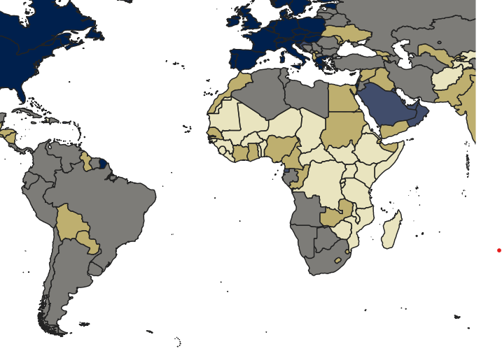
The 2030 Agenda for Sustainable Development, announced by the United Nations in 2015, is a plan of action for people, planet and prosperity. It defines 17 Sustainable Development Goals (SDGs) and 169 targets for tracking progress of the SDGs. Since its announcement, indicator data for tracking these targets have been collected (https://unstats.un.org/sdgs/dataportal/), made available and included in graphs and maps in reports, posters, websites and dashboards, etc., very often showing the state and progress of SDG indicators on a global map (e.g., https://datatopics.worldbank.org/sdgatlas?lang=en and https://ourworldindata.org/sdgs). Small Island Development States (SDIS) are located in the Caribbean, the Pacific, and the Atlantic, Indian Ocean and South China Sea. Due to their small resource base and because they are often in remote areas with infrequent international traffic, SIDS face significant environmental and developmental challenges. For example, the optimal management of scare, interconnected and interdependent environmental resources is significantly more challenging than in other settings (Brouwer et al. 2023, https://wefnexusindex.org/). Raising awareness of these challenges and tracking progress is essential, however, on a global map of the world, the island states are barely visible. This problem is further compounded on multi-variate thematic maps. Gosling-Goldsmith et al. (2020) showed how the choice of projection and central meridian can improve the visibility of SIDS on a global map (https://gip-itc-universitytwente.github.io/SIDS/). However, there are many other design choices (Kraak et al. 2020) and map designs (Huang et al. 2005; Battersby et al. 2011) to be explored.
For this topic, the aim is to investigate, develop and assess thematic map designs and/or tools for improving the visibility of small island development states on thematic maps of SDG or Resource Nexus (e.g., water-energy-food) indicators. There are various research avenues to consider for this topic, depending on the interests and expertise of the student, such as experimenting and evaluating novel map designs (static and/or interactive), conducting a user study to assess the effectiveness of map designs/design choices, or develop tools, such as QGIS plug-ins for interactive solutions. The different research avenues could also be combined in a single project.
Literature/references:
Battersby, S. E., Stewart, J. E., Fede, A. L. D., Remington, K. C., & Mayfield-Smith, K. (2011). Ring maps for spatial visualization of multivariate epidemiological data. Journal of Maps, 7(1), 564–572. https://doi.org/10.4113/jom.2011.1182
Brouwer, F., Caucci, S., Karthe, D. et al. Advancing the resource nexus concept for research and practice. Sustainability Nexus Forum 31, 41–65 (2023). https://doi.org/10.1007/s00550-024-00533-1
Gosling-Goldsmith J, Ricker B & Kraak M-J (2020). Topographic and thematic (in)visibility of Small Island Developing States in a world map, Journal of Maps, 16:1, 50-56, https://doi.org/10.1080/17445647.2020.1736194
Huang, G., Govoni, S., Choi, J., Hartley, D. M. and Wilson, J. M. (2005) Painting a Truer Picture of US Socioeconomic and Racial/Ethnic Health Inequalities: The Public Health Disparities Geocoding Project, American Journal of Public Health, 95, 312–323.
Kraak MJ, RE Roth, B Ricker, A Kagawa, and G Le Sourd. 2020. Mapping for a Sustainable World. United Nations: New York, NY (USA)