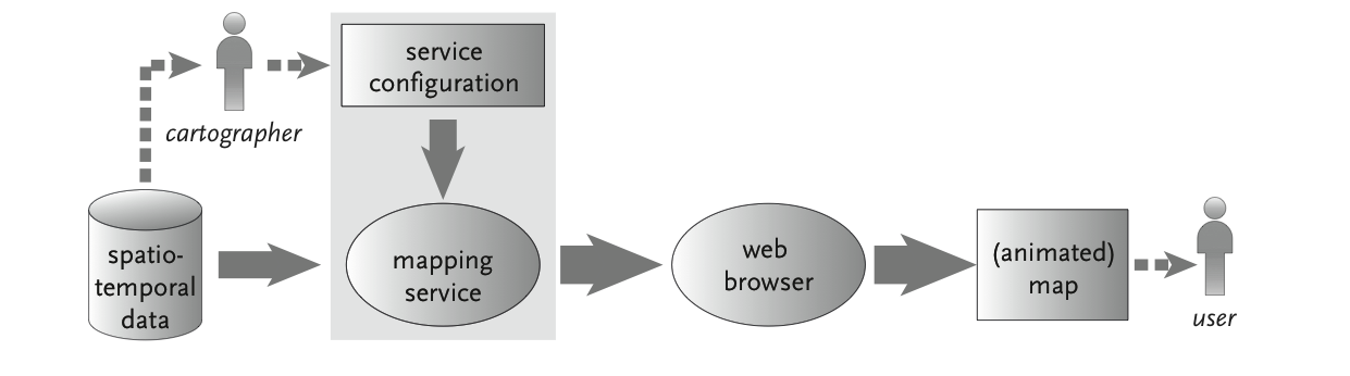
 Fig. 1. Current practice of dissemination of maps
in a webservices
environment.
Fig. 1. Current practice of dissemination of maps
in a webservices
environment.
Until recently I was active in the two "old" GIP research themes: I
worked on the SDI–light OSGEO software stack. This dealt with
implementing geowebservice components in a simple, stable and
cost–effective setup, using an SDI software stack that is built out of
free and open source components. Furhermore I was looking into spatio-temporal
geo-webservices. The goal of this was extending W*S and other
geo-webservices with time series data output as animated, interactive
vector maps. Work was done in bringing the Open Source project
RIMapperWMS further by integration of TimeMapper code it (see kartoweb.itc.nl/rimapper/)
The intention is to go forward with parts of these research matters
within the new departemental research theme STAMP (Spatio–Temporal
Analytics, Maps and Processing). I want to look further in facilitating
the production of (animated) maps from spatio–temporal data to a format
suitable for internet dissemination, automatically and directly. To
achieve that, I want to look specifically into the possibilities of the
loose coupling of distributed webservices with animated, interactive
vector maps. By ‘direct’ I mean that the maps are generated on–the–fly
from the data, without conversion or pre-processing needed. This is
necessary because the map generation should fit in an interoperable
Spatial Data Infrastructure. ‘Automatic’ in currents systems means that
the maps are generated from the spatio-temporal data by the system
“working by itself with little or no direct human control”. But this
automation at present does not include the cartographic decisions as to
what type of map to use for different data–types and data–instances.
The link between data type and visualisation has to be made by a human
(the cartographer in Figure 1), setting up the appropriate
configuration parameters beforehand.
Fig. 1. Current practice of dissemination of maps
in a webservices
environment.
Fully automated mapping from data, with
cartographic design decisions
included, remains an interesting research
challenge that I want to look into. I have discussed this issue in
several places, e.g. at the EuroSDR WebCartography workshop. There
seem to be several approaches for this problem, and a promising one is
the use of a formal map specification
language.
This would be a
formalised specification (in the computer science sense) that defines
the desired outcome using a declarative language. This language should
have defined degrees of freedom (e.g. ranges of acceptable values) that
allow for map creation in a controlled and consistent manner. It could
be used by a service compiler that creates a service configuration file
(e.g. an SLD) based on the formal map specification, plus (meta–)data
and user input. The possible set-up is sketched in Figure 2.
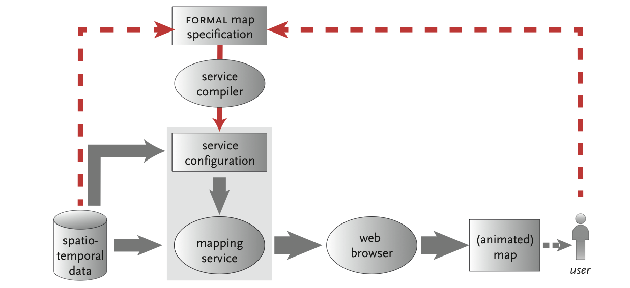 Fig. 2. The possible role of a
formal map specification
in a webservices environment.
Fig. 2. The possible role of a
formal map specification
in a webservices environment.
Testing platforms for such a set-up could be the experimental 3rd edition of the National Atlas of the Netherlands (as use case) and the RIMapper/TImeMapper services (as prototype software environment). The main research question could be formulated as
Can we use a formal map specification language to facilitate, in a distributed webservices environment, the automatic generation of maps from spatio–temporal data in a format suitable for internet dissemination?
Research keywords: automated mapping, geo-webservices,formal map specification