 To
the ICA Seminar Proceedings
To
the ICA Seminar Proceedings
Published as:
B.J. Köbben and M. Yaman (1995). Evaluating dynamic visual variables. In: Seminar on Teaching Animated Cartography, F.J. Ormeling et al. (ed.). Madrid/Utrecht: International Cartographic Association, pp. 45-53.
Introduction
This paper describes preliminary tests for evaluating the perceptual properties of dynamic visual variables. During research into cartographic animations, it was found very little is known about the effects of dynamic visual stimuli, such as animated maps, on map-users. Whereas these effects are well researched in regard to static visual variables, no such knowledge is present for dynamic visual variables. In order to shed some light into this, some -fairly limited- test animations were developed to give a first insight into these perceptual properties of dynamic visual variables.First the two main means of depicting dynamic phenomena in map form will be discussed, on the one hand static maps and map series and on the other cartographic animations.
Secondly, the tools available for making cartographic animations will be described: the visual variables. Apart form the well-known static visual variables (size, value, grain, colour, orientation and form), dynamic visual variables will be introduced: moment, duration, frequency, order, rate of change and synchronisation.
Next the tests for determining the perceptual properties of these dynamic visual variables are described ass well as the conclusions drawn from these tests.
Using static maps to show dynamic phenomena
It is not strictly necessary to use dynamic visual stimuli, such as cartographic animations, in order to depict dynamic phenomena. Cartographers have been successfully mapping moving things without animations for centuries. Although the passage of time can not be visualised directly on the two dimensions of a paper map, it can be simulated quite effectively, using either single maps or map series. On single maps we can indicate movement by drawing arrows, or suggest it by drawing lines which indicate the location of phenomena at certain times (see figure 1).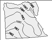
By using a series of maps we can give the viewer an impression of the passing of time or some other change from map to map. With these time-series maps it's up to the user to interpolate between the individual maps, thus giving the impression of a smooth development in time.
Using cartographic animations to show dynamic phenomena
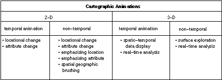
So it is possible to depict dynamic phenomena using static visual stimuli. Nevertheless, it appears most logical to use dynamic visual stimuli to do so. As early as 1959, Thrower pointed out that cartographers should adapt to the growing possibilities of audio-visual communication. Now that cheap and powerful computers are bringing multi-media to the homes, the "Nintendo generation" of today just won't notice anything that doesn't move and makes sound. Cartographers are almost forced into using the possibilities to "bring life" to their maps. Although people often think of animation as synonymous with motion, it covers all the changes that have a visual effect. It thus includes the time-varying position (motion dynamics), shape, colour, transparency, structure and texture of an object (update dynamics) and changes in lightning, camera position, orientation and focus and even changes in rendering techniques (foley et al, 1990 ).The use of animation for maps, or cartographic animations has been the focus for research for a number of years now. From this several types of cartographic animations can be distinguished, as seen in figure 2.
Although the different types will not be covered in this paper, the
important difference between temporal and non-temporal animations spould
be explained.
In temporal animations the display time and the world time
are directly related. Display time is the moment in time the user gets
to see the individual frames that make up an animation. To give the illusion
of smooth movement, there should be a minimum of 24 frames per second.
World time is the actual moment in time the depicted phenomena did take
(or is taking) place. An example of a temporal animation would be showing
presence of rainfall in the Netherlands at a rate of 1 hour per frame.
Thus the highlighting of the province of Utrecht for 1 second would indicate
it has rained there for a day.
Non-temporal animations have no direct relation between display
time and world time . Display time could be used here to indicate
the amount of rainfall. Here the highlighting of the province of Utrecht
for 1 second could perhaps mean that 100 mm of rain fell in one month,
while the province of Limburg is highlighted for 2 seconds, indicating
a rainfall of 200 mm per month.
Dynamic visual variables
Bertin (1967) did not have much confidence in the usefulness of dynamic maps. He stated that the motion would dominate the graphic variables he distinguished (size, value, grain, colour hue, orientation and shape), thus disturbing the effectiveness of the cartographic message. But then again, Bertin didn't like colour much either...Contrary to Bertin's opinion, recent research by DiBiase et al. (1992) and Koussoulakou & Kraak (1992) has shown that visual variables can indeed be used on the individual frames of an animation in such a way that these images effectively communicate the cartographic message to the user, while the movement of the animation gives the message an extra dimension and "new energy". Furthermore, the findings of Koussoulakou & Kraak (1992) showed that using animated maps helped users grasp the contents of a message in a more effective manner compared to using traditional static maps or map series.
It has become clear that the traditional visual variables, which we will call the static visual variables from here on, do not suffice in describing the added means of expression we have in cartographic animations. To this end six "new" visual variables have been introduced by DiBiase et al. (1992 ) and MacEachren (1994) . These will be called the dynamic visual variables from here on.
They are:
- moment
- duration
- frequency
- order
- rate of change
- synchronisation
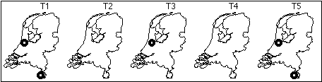
The moment that an element in the map changes during a cartographic animation can be used for temporal as well as non-temporal animations. An example of a non-temporal animation could be the appearance of some activity in Spain and Portugal (figure 3).
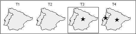
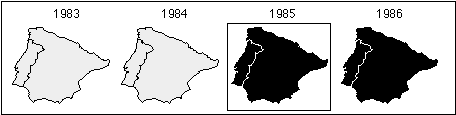
Figure 4 indicates these countries joining the European Community, which is directly related to world-time and therefore an example of a temporal animation.
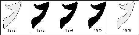
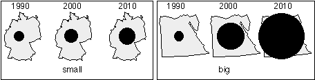
Duration
Duration indicates the duration in real-time an element is visible
during an animation. If province A has twice the amount of annual sunshine
of province B, province A would be highlighted twice as long during the
animation. This would of course be an non-temporal use of duration, whereas
the duration in the example in figure 5 is an example of temporal use of
duration.
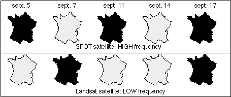
Frequency
The dynamic visual variable frequency uses the rate of occurrence of
graphical elements. In Figure 6, the high "blinking" frequency of Schiphol
airport indicates its bigger importance compared to Beek airport in the
southern province of Limburg.
Of course, frequency can also be used for temporal animations, as figure 7 shows.
Order
Animation actually is the presentation of individual frames in a given
order. Chronologically showing temporal data is probably the most used
form of cartographic animation. Figure 8 uses this technique to depict
the dates of independence of African states.
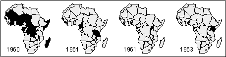
Although most used for these temporal animations, order can also be
used in non-temporal animations and sometimes a selective non-chronological
sequence is best to emphasise relations between certain phenomena (weber
& buttenfield, 1993 ).
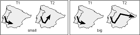
Rate of change
The rate of change can be described as M/D, where M is the change magnitude
and D is the duration of each scene. With change magnitude (M) the amount
of change of the position and/or attribute value of an object between to
subsequent scenes is decsribed. The value of M depends on how dynamic the
phenomenon is and on the pace of the animation (ie. how many frames per
minute). If M increases while D remains the same, the animation will become
more abrupt and "jerky". If D increases while M remains constant, the apparent
change to the viewer decreases. These are powerful tools in manipulating
the viewers' perception and should be used with some care.
Rate of change can be used in both temporal and non-temporal animations,
as the examples in figure 9 and 10 show.
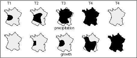
Synchronisation
With synchronisation two (or more) phenomena are related to each other
by showing their development synchronously in one animation. For instance,
in figure 11 the viewer should perceive the effects the rainfall has some
time later on the growth of vegetation. This only works for fairly straightforward
temporal relationships.
Perceptual properties of dynamic visual variables
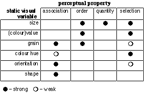
Cartographers normally don't make maps for other cartographers, but for map-users. That's why there always should be the question "what do we want the user to learn from this map?" in the back of mapmakers' minds. Just as much as for traditional static maps, this is true for cartographic animations. The goal of the animation can only be achieved if the visual variables used, be they static or dynamic, give the user the desired stimuli, thus helping him to understand the phenomena depicted.Therefore the kind of stimuli the visual variables give to viewers should be understood. These stimuli are called the perceptual properties of visual variables and they are:
Association: There is association between graphic elements if they are perceived as similar. Association is therefore useful to indicate groups of different quality or character.
Order: Lets the viewer perceive the graphic elements as ordered (more/less; sooner/later).
Quantity: The graphic elements give the viewer an impression of proportional differences (twice/half as much).
Selection: Because the graphic elements are perceived as different and belonging to families, this lets the viewer get a prompt and lasting impression of the phenomena depicted (recognition/overview).
Much research has gone into this regarding the static visual variables, resulting in generally accepted perceptual properties for them (figure 12).
It should be clear that we need to know the perceptual properties of
the dynamic visual variables as well. In recent literature this need has
been stressed quite often, but not much work has been undertaken so far
into actually finding out these perceptual properties.
As part of an MSc-thesis at the Cartography department of Utrecht University,
some limited preliminary studies into this problem were done by testing
reactions of viewers on the use of dynamic visual variables in cartographic
animations.
The tests
These test are only a first attempt to shed some light into the subject matter and should be considered an impulse for further research. Only ten persons were tested, all of them professional cartographers or cartography students.In order to test the perceptual properties of the dynamic visual variables, it was necessary to isolate them from the traditional static visual variables. In other words, the animations used in the tests should deploy only one of the dynamic visual variables, with no other visual stimuli to aid in understanding the message.
Because there is a strong suspicion, from literature and common sense, that a combination of dynamic visual variables with one or more static visual variables would improve the impact of the animation, this was also tested.
All in all some 12 animations were constructed, using the authoring software MacroMedia Director 4.0 on an Apple Macintosh computer. Because it proved to be impossible with this to construct a useful animation deploying synchronisation, testing this dynamic visual variable failed.
For every animation two categories of questions were asked. The first category was used to determine if the animation had any of the perceptual properties we searched for. They included questions like "do you think these countries belong to the same class" or "can you find a pattern in the desertification process depicted?" With the second group of questions we tried to find how strongly the perceptual property was. All questions were posed orally and apart from the answers all comments given were also noted.
Conclusions drawn from the tests
The test results, summarised in figure 13, tell several things. The dynamic visual variable moment appears to be not very useful for cartographic animations. Only in combination with the static visual variable colour, some subjects could understand it's meaning.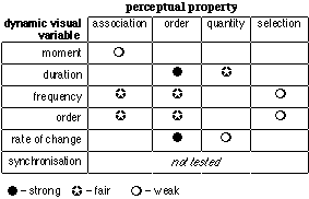
Reaction to the use of duration were mostly positive. Animations
using duration conveyed a strong sense of order and some sense of quantity
was attained, especially when a legend was included. A distinct drawback
was the long durations which were sometimes necessary to distinguish the
classes, resulting in comments about "boredom" and "fading interest".
Frequency was mostly regarded as fairly effective. Most subjects
found it hard to grasp the meaning of these animations at first and with
these animations especially, it was found important that users could control
them, i.e. stop and 'rewind' on demand.
The dynamic visual variable order seems to be most effective
for depicting quantitative or spatio-temporal data that actually was ordered.
When used for qualitative data, most subjects where so confused, they thought
that the order depicted some (non-existing) order in the data.
Rate of change proved to be very effective in communicating
a sense of order and, to a lesser degree, of quantity. But the maximum
number of classes that it can be used for seems quite limited.
Perhaps the most important conclusion has to be that selection, which
is so important in making cartography a strong tool for communication,
can not be effectively attained by using dynamic visual variables alone.
Therefore it seems that dynamic visual variables will only render favourable
results in the use of cartographic animations.when combined with the traditional
static visual variables
References
Bertin, J. (1967). Semiologie Graphique, Paris/Den Haag: Mouton.DiBiase, D et al. (1992). Animation and the role of map design in scientific visualisation. Cartography and GIS, 19 (1992) 4, pp.201-214.
Foley, J.D. et al. (1990). Computer Graphics: Pronciples and practice. Reading: Addison-Wesley.
Koussoulakou, A. & M.J. Kraak (1992). Spatio-temporal maps and cartographic communication. The Cartographic Journal, 29 (1992) 2, pp. 101-108.
Kraak, M.J. (1992). Kartografie en multi-media: De ruimte-tijd kaart. NVK Publicatiereeks nr. 5 (Multimedia en Kartografie), pp. 23-31.
MacEachren, A.M. (1994). How maps work: Issues in representation & design. New York: Guildford Press.
Thrower, N.J.W. (1959). Animated Cartography. The professional geographer, 11 (1959) 6, pp. 9-12.
Weber, C.R. & B.P. Buttenfield (1993). A cartographic animation of average yearly surface temperatures for the 48 contiguous United States: 1897-1986. Cartography and GIS, 20 (1993) 3, pp. 141-150.
To
the ICA Seminar Proceedings